

Hollowing out old Kashgar
New web tools make it easier than ever to track depressing things like the obliteration of historic cities. The great blog Ogle Earth has two posts documenting the destruction of Old Kashgar, in China's Xinjiang province. Until recently it was the “the best-preserved example of a traditional Islamic city to be found anywhere in central Asia.” These presentations show the power of Google Earth as a monitoring tool for urban conservation.
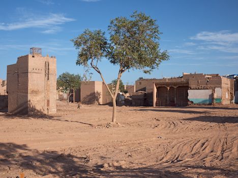
Until August, this was a dense network of traditional courtyard houses.
Stefan Geens spent a week in Kashgar in August documenting the demolition, and has a great post with photo gallery (the photos here are his).
I have learned from living in Shanghai and now Beijing that Chinese authorities — and to a certain extent mainstream Chinese culture — do not attach much importance to protecting traditional vernacular architecture. Imperial palaces and grand religious temples are worthy of preservation or even reconstruction, but not on the whole the hutong of Beijing or the lane houses of Shanghai, which are deemed too ordinary, especially when there is money to made building high-rises in their stead.He made a .kmz file for Google Earth so you can track the bulldozers yourself:
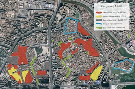
Basically, the government is keeping some attractive façades for the tourists, while destroying the neighborhoods behind it: an example of façadism at its worst.
Why hasn't tourism been a better incentive for preservation? You do see the occasional westerner exploring the town, but the overwhelming majority of tourists in Kashgar are affluent visitors from within China, and they uniformly travel in bussed tour groups, deposited at various locales where they are led to photogenic spots by guides bearing portable loudspeakers. Among these destinations are the two officially protected parts of the old town, the 15% where bulldozers won't tread. These neighborhoods have been turned into open-air museums, with an entrance fee (RMB 30, USD 4.40) that entitles access to various courtyard homes and souvenir shops. I suspect that the Chinese authorities think these two areas should suffice for the majority of tourists. Depressingly, they may be right.In a more recent post, he also dug up a 1908 map and superimposed it on the current city plan, so you can see what has changed, and what hasn't. The .kmz file is here.
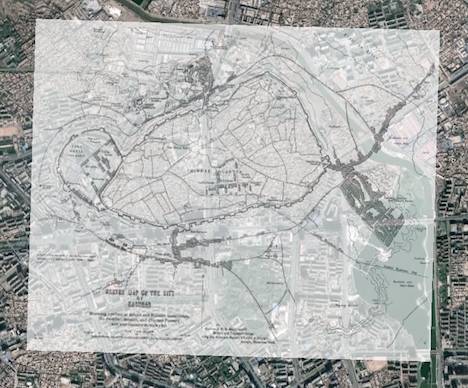
Geens reflects on what you can see in the overlay:
Right away, it also becomes clear that the river's course used to lie further East, across lowlands that are now decked in relatively modern buildings. The maps's main discrepancy can be found in the size and orientation of the settlement to the Southeast of the city; the fortress to the west is also larger than life. In the Eastern half of the cities, the topology of the mapped alleys is tantalizingly familiar, though without producing accurate matches.It goes without saying that the destruction of Old Kashgar is an instance of cultural warfare. The government would like to pacify and/or eliminate the local Uyghur culture, which is Turkic, Muslim, and not always especially thrilled to be part of China - especially after (successful) efforts to ensure that Uyghurs become an ethnic minority in their own territory. After last year's bloody riots between Uyghur and Han, tensions still remain high in the region. Heritage Key asks whether granting UNESCO World Heritage status would stop the destruction - an idle question, since UNESCO only inscribes sites nominated by member states, and has no particular incentive to provoke China. And for Chinese planners, like their American counterparts in the 1950s, the old is just an impediment to progress, which is obviously best implemented by stuffing everyone into concrete towers that are shabby almost before they're even finished.

No comments:
Post a Comment